# Center Camera In Bounds
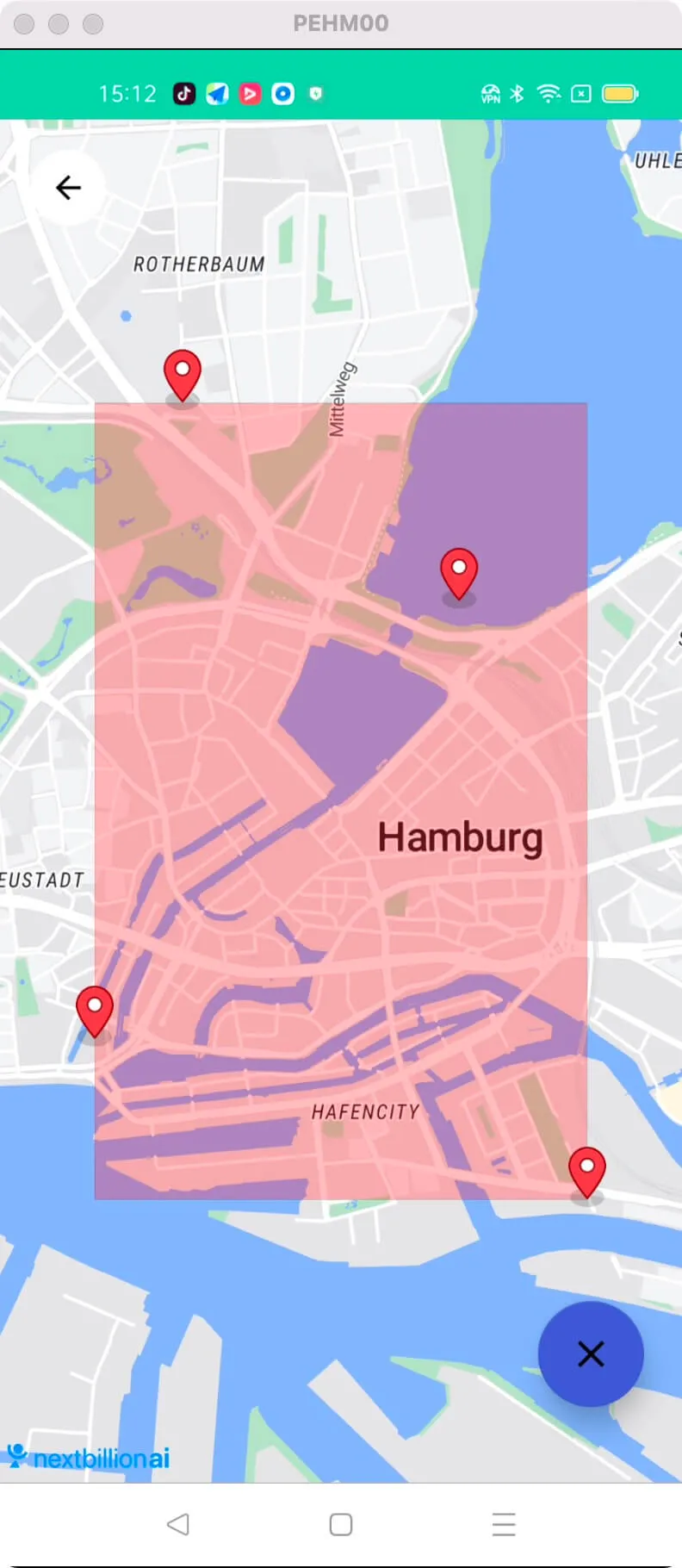
This example shows how to Center Camera in Bounds
- Create polygon with custom bound area
- Center Camera to given bounds and padding
- mMap.animateCamera(CameraUpdateFactory.newLatLngBounds(bounds, 150))
For all code examples, refer to [Android Maps SDK Code Examples](https://github.com/nextbillion-ai/nb-maps-android-demo)
activity_bounds.xml view source
```xml
```
BoundsActivity view source
```java
package ai.nextbillion;
import ai.nextbillion.databinding.ActivityBoundsBinding;
import ai.nextbillion.maps.annotations.PolygonOptions;
import ai.nextbillion.maps.camera.CameraUpdateFactory;
import ai.nextbillion.maps.core.NextbillionMap;
import ai.nextbillion.maps.core.Style;
import ai.nextbillion.maps.geometry.LatLng;
import ai.nextbillion.maps.geometry.LatLngBounds;
import android.graphics.Color;
import android.os.Bundle;
import android.view.LayoutInflater;
import androidx.appcompat.app.AppCompatActivity;
/**
* @author qiuyu
* @Date 2022/6/30
**/
class BoundsActivity : AppCompatActivity(){
private lateinit var binding: ActivityBoundsBinding
private lateinit var mMap: NextbillionMap
private var boundsPoints: MutableList = mutableListOf()
private var boundsArea: PolygonOptions? = null
override fun onCreate(savedInstanceState: Bundle?) {
super.onCreate(savedInstanceState)
binding = ActivityBoundsBinding.inflate(LayoutInflater.from(this))
setContentView(binding.root)
binding.mapView.onCreate(savedInstanceState)
binding.mapView.getMapAsync { map: NextbillionMap -> onMapSync(map) }
binding.removeBounds.setOnClickListener {
removeBounds()
}
binding.ivBack.setOnClickListener {
finish()
}
}
private fun removeBounds() {
mMap.clear()
boundsPoints.clear()
boundsArea = null
binding.removeBounds.hide()
}
private fun onMapSync(map: NextbillionMap) {
mMap = map
mMap.addOnMapLongClickListener {
checkBounds(it)
false
}
map.setStyle( Style.Builder().fromUri(StyleConstants.LIGHT))
}
private fun checkBounds(latLng: LatLng) {
mMap.addMarker(latLng)
boundsPoints.add(latLng)
if (boundsPoints.size >= 4) {
binding.removeBounds.show()
boundsArea?.let {
mMap.removePolygon(it.polygon)
}
val bounds = LatLngBounds.Builder().includes(boundsPoints).build()
mMap.setLatLngBoundsForCameraTarget(bounds);
boundsArea = PolygonOptions()
.add(bounds.northWest)
.add(bounds.northEast)
.add(bounds.southEast)
.add(bounds.southWest)
boundsArea?.let {
it.alpha(0.25f)
it.fillColor(Color.RED)
mMap.addPolygon(it)
}
mMap.animateCamera(CameraUpdateFactory.newLatLngBounds(bounds, 150))
}
}
///////////////////////////////////////////////////////////////////////////
// Lifecycle
///////////////////////////////////////////////////////////////////////////
override fun onStart() {
super.onStart()
binding.mapView.onStart()
}
override fun onResume() {
super.onResume()
binding.mapView.onResume()
}
override fun onPause() {
super.onPause()
binding.mapView.onPause()
}
override fun onStop() {
super.onStop()
binding.mapView.onStop()
}
override fun onSaveInstanceState(outState: Bundle) {
super.onSaveInstanceState(outState)
binding.mapView.onSaveInstanceState(outState)
}
override fun onDestroy() {
super.onDestroy()
binding.mapView.onDestroy()
}
override fun onLowMemory() {
super.onLowMemory()
binding.mapView.onLowMemory()
}
}
```
The given code is an Android activity that allows users to create a polygon by selecting points on a map. It also provides the functionality to remove the created polygon.
Initializing the MapView:
- The MapView is initialized in the onCreate method using **binding.mapView.onCreate(savedInstanceState)**.
- The map is obtained asynchronously using **binding.mapView.getMapAsync** and the **onMapSync** method is called.
Creating a Polygon with Custom Bound Area:
- The **onMapSync** method sets up the NextbillionMap and adds a map long click listener.
- When a long click event occurs, the checkBounds method is called with the clicked **LatLng** coordinate.
- The clicked LatLng is added to the boundsPoints list, and a marker is placed at that location on the map.
- If there are at least 4 points in the boundsPoints list, a polygon is created with the bounds using **LatLngBounds.Builder().includes(boundsPoints).build()**.
- The existing bounds area is removed from the map using **mMap.removePolygon(it.polygon)**.
- A new **PolygonOptions** object is created and added to the map with the appropriate points and styling.
- The camera is animated to center on the created bounds using **mMap.animateCamera(CameraUpdateFactory.newLatLngBounds(bounds, 150))**.
Centering Camera to Given Bounds and Padding:
- The **mMap.setLatLngBoundsForCameraTarget(bounds)** method is used to set the bounds for the camera movement.
- The camera is animated to center on the created bounds with a padding of 150 pixels.
Removing Bounds:
- The **removeBounds** method is called when the "removeBounds" button is clicked.
- It clears the map, clears the boundsPoints list, sets boundsArea to null, and hides the "removeBounds" button. Lifecycle Methods:
The code also includes various lifecycle methods **(onStart, onResume, onPause, onStop, onSaveInstanceState, onDestroy, onLowMemory)** that should be implemented when using the MapView to properly manage its lifecycle and handle configuration changes.
_Note_: The code uses the Nextbillion Maps SDK, which provides map-related functionalities. It also utilizes the LatLng class to represent geographical coordinates and the LatLngBounds class to define a rectangular area on the map.